


l diheen

mlmoroneybb
User
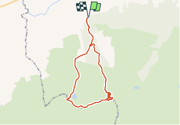

Length
16.3 km

Max alt
910 m

Uphill gradient
1194 m
Km-Effort
32 km

Min alt
134 m

Downhill gradient
1194 m
Boucle
Yes
Creation date :
2014-12-10 00:00:00.0
Updated on :
2014-12-10 00:00:00.0
5h46
Difficulty : Difficult

FREE GPS app for hiking
 SityTrail
IGN / Geographical institutes
SityTrail Plus
The world is yours!
About
Trail Walking of 16.3 km to be discovered at Unknown, County Tipperary, The Municipal District of Cahir — Cashel. This trail is proposed by mlmoroneybb.
Description
Hard walk
Photos


Positioning
Country:
Ireland
Region :
Unknown
Department/Province :
County Tipperary
Municipality :
The Municipal District of Cahir — Cashel
Location:
Clonbeg
Start:(Dec)
Start:(UTM)
555470 ; 5806056 (29U) N.
Comments